$216,000
$219,000
1.4%For more information regarding the value of a property, please contact us for a free consultation.
214 E Cline Crossing -- #- Young, AZ 85554
33.8 Acres Lot
Key Details
Sold Price $216,000
Property Type Vacant Land
Listing Status Sold
Purchase Type For Sale
MLS Listing ID 6264672
Sold Date 01/31/22
HOA Y/N No
Originating Board Arizona Regional Multiple Listing Service (ARMLS)
Annual Tax Amount $3,018
Tax Year 2020
Lot Size 33.804 Acres
Acres 11.9
Lot Dimensions 990'X524'
Property Description
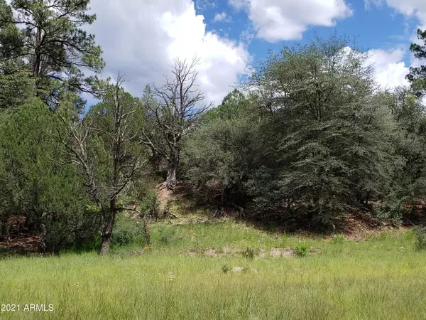
GORGEOUS MEADOW DOTTED and RINGED with MATURE OAK, PONDEROSA PINE & WALNUT TREES! VERY PRIVATELY LOCATED EAST of CHERRY CREEK AGAINST TONTO NATIONAL FOREST!! RARE OPPORTUNITY to OWN EXTREMELY PRIVATE, USABLE, BUILDABLE LAND with DEAD END ROAD ACCESS. Seller re-surveying existing Map 1977 to move easement to westerly side of property and changing gross acreage amount of subject property to 11.8 +/- acres. Access through Cherry Creek which is physically located on neighbor's property to the west. 3 owners of adjoining parcels will cooperate in a private road maintenance agreement. APS electric poles and overhead line on neighbor's land, adjacent to south property boundary. Buyer to so soils analysis and install a septic system. Private water well will need to be drilled for domestic water. Land line telephone and high speed fiberoptic Internet cable in Cline Crossing easement. Ideal for gardening and other homesteading activities! Build for views on the treed hillside in northeasterly corner that directly adjoins Tonto National Forest. Legal description will change when the new survey map is recorded; lot dimensions reported are estimated. Property tax amount for 2020 was charged by Gila County for entire 33.8 +/- acres. 911 street address is estimated. Gila County will assign a permanent street address number when lot is developed.
Location
State AZ
County Gila
Zoning unclassified
Direction Hwy 288 to Cline Crossing, near mile marker 310.9. E on Cline Xing; hike across Cherry Creek; go thru opening in fence on left. Parcel C is the southerly portion of the original 33.8-acre property.
Exterior
Fence Partial, Wire
Waterfront No
Topography Level
Building
Lot Description Borders Pres/Pub Lnd
Sewer None
New Construction Yes
Schools
Elementary Schools Out Of Maricopa Cnty
Middle Schools Out Of Maricopa Cnty
High Schools Out Of Maricopa Cnty
School District Out Of Area
Others
Senior Community No
Tax ID 305-20-004-A
Acceptable Financing Seller May Carry, CTL
Horse Property Y
Horse Feature Other, See Remarks
Listing Terms Seller May Carry, CTL
Financing Cash
Read Less
Want to know what your home might be worth? Contact us for a FREE valuation!

Our team is ready to help you sell your home for the highest possible price ASAP

Copyright 2024 Arizona Regional Multiple Listing Service, Inc. All rights reserved.
Bought with Waite's Country Realty


